

Road networks deteriorate gradually and unevenly. Identifying defects at an early stage — before minor surface damage becomes a structural failure — requires inspection at a frequency and scale that traditional methods cannot sustain cost-effectively. IDL's General Road Quality Inspection service provides highway authorities, road operators, and asset owners with a systematic, AI-powered approach to continuous pavement monitoring across entire network segments.
Rather than relying on periodic manual surveys that produce inconsistent, inspector-dependent results, our platform converts drone-captured aerial imagery into a structured, georeferenced database of pavement conditions — updated on a schedule aligned with your maintenance and budget cycle.
Managing extended road networks requires more than reactive maintenance. Authorities and operators face several compounding problems with conventional inspection approaches:
The result is a chronic gap between actual network condition and decision-makers understanding of it — leading to inefficient resource allocation, deferred maintenance, and elevated risk.


IDL deploys licensed drone operators to conduct systematic aerial surveys of defined road segments. Imagery is captured at standardised altitude, overlap, and resolution parameters to ensure consistent data quality across all survey epochs. The raw data is uploaded to our cloud- based processing platform, where proprietary computer vision models classify and measure defects automatically.
The system evaluates each road segment across a comprehensive set of condition indicators:
Each defect is georeferenced, classified by type and severity, and assigned a condition score against predefined quality criteria. The output is a complete, segment-level compliance dataset — not a PDF of photographs, but structured data directly usable in asset management systems.
Where multiple survey epochs exist, the platform performs automated change detection: identifying sections where deterioration has accelerated, quantifying the rate of degradation, and flagging segments approaching intervention thresholds. This transforms inspection data into a predictive maintenance input.
Following each survey, the platform generates:
All raw imagery, processing outputs, and reports are stored securely within the platform for a minimum recommended retention period of five years, providing a defensible evidence base for audits, warranty claims, and dispute resolution.
reduction in
inspection time
cost savings vs.
manual methods
precision in
defect classification
from scan
to results

Road markings are a primary safety communication channel between infrastructure and road users. Faded centre lines, misaligned lane boundaries, or incorrectly positioned prohibition markings do not merely represent a compliance failure — they directly influence driver behaviour and contribute to accident risk. Yet verifying marking quality across extended road networks has historically depended on slow, subjective, and legally fragile manual inspection processes.
IDL's Road Marking Analysis service provides a rigorous, AI-powered platform for the automated verification of road markings against design specifications, national standards, and tolerance thresholds — at any scale, with results available within 50 seconds of data upload.
Road marking inspection is operationally complex for several reasons that make conventional approaches inadequate:


IDL's platform addresses marking inspection through two differentiated analytical scenarios, applied depending on whether the markings under review are newly installed or previously existing.
Scenario A — New Markings vs. Design Compliance
For newly constructed or freshly marked pavements, the system verifies actual marking positions against uploaded project design layers (GIS/CAD files, design alignment files, or georeferenced drawings).
Detected markings are cross-referenced with design specifications to confirm:
Scenario B — Renewed Markings vs. Standards Tolerances
For repainted or restored markings, absolute positional comparison against original design is often impractical. Instead, the platform applies a standards-based geometric conformity assessment within permitted tolerance bands.
This approach detects:
In both scenarios, when GPS metadata is embedded in the drone imagery, marking elements are automatically georeferenced to the project alignment. Where GPS accuracy is insufficient, the platform supports manual referencing to chainages, stations, or design alignment files — ensuring full analytical utility regardless of hardware limitations or site conditions.
Each completed Road Marking Analysis produces:
All evidence — raw imagery, analytical outputs, georeferenced data, and final reports — is retained within the platform for five years, providing a chain-of-custody record suitable for dispute resolution and legal proceedings.
from scan
to results
defect
precision
faster than
manual survey
cost
savings

Railway infrastructure operates under some of the most demanding safety and reliability requirements of any engineered asset class. Track geometry defects, ballast displacement, vegetation encroachment, and deteriorating drainage structures can all compromise operational safety — yet the very nature of active rail operations makes traditional inspection methods costly, infrequent, and operationally disruptive.
IDL's Railway Infrastructure Monitoring service enables continuous, non-disruptive aerial inspection of rail corridors using AI-powered drone analytics. The platform delivers structured condition data and documented maintenance intelligence without requiring track access closures, specialised inspection vehicles, or interruption to scheduled services.
Railway operators, infrastructure managers, and concession holders face a specific and compounding set of inspection challenges:
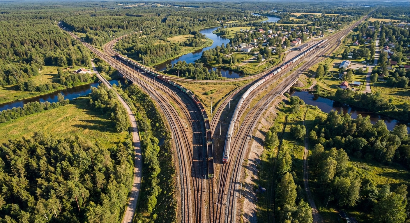

IDL deploys certified drone operators to conduct aerial surveys of rail corridors at defined intervals — monthly, quarterly, or seasonally — according to the asset criticality and maintenance cycle of the client. Flights are planned and executed in full compliance with applicable aviation regulations and railway safety protocols, with no interference to live operations.
High-resolution imagery and video are captured along the full corridor width, including track, formation, embankments, drainage features, and adjacent vegetation zones.
Data is processed by AI models specifically trained on railway asset classes, delivering:
Each asset element is classified, georeferenced to track chainage, and assigned a condition rating. Where multiple survey epochs are available, the platform performs automated change detection — quantifying the rate of deterioration for each element category and flagging assets approaching intervention thresholds. This enables maintenance teams to transition from reactive repair to planned, evidence-based intervention.
Following each survey cycle, the platform delivers:
Reports are formatted to align with the client's maintenance management system requirements and applicable national railway infrastructure standards.
reduction in
inspection time
service
disruptions
detection
precision
evidence
retention

Large-scale construction projects, critical infrastructure sites, and sensitive land areas share a common challenge: conditions on the ground change continuously, and the consequences of undetected change — whether a structural deviation, an encroachment, or a security breach — can be severe and costly to reverse. Traditional site monitoring relies on infrequent walk-arounds, static CCTV, and manual photographic records that provide incomplete, inconsistent, and legally fragile evidence.
IDL's Site Monitoring & Change Detection service provides a systematic, evidence-based alternative. Through scheduled drone surveys combined with AI-powered comparison analysis, the platform creates a continuous, time-stamped visual record of any defined area — automatically identifying, documenting, and classifying material changes between survey epochs.
Clients responsible for managing active construction sites or critical infrastructure zones face a consistent set of monitoring failures with conventional approaches:


IDL establishes a repeatable aerial survey programme for each monitored site, with flight frequency calibrated to the pace of activity and the client's risk profile — ranging from weekly surveys on active construction projects to monthly or quarterly overflights for slower-changing infrastructure or land areas.
Each survey follows a standardised flight plan to ensure precise spatial alignment with prior epochs, enabling pixel-accurate change detection. The resulting dataset is processed by AI models that automatically compare current conditions against the established baseline or the most recent prior survey, identifying and classifying changes across the full site footprint.
The platform monitors and documents:
Each detected change is georeferenced, timestamped, classified by category and significance, and linked to photographic evidence. The platform generates a change log that constitutes a defensible, time-ordered record of site conditions — suitable for construction programme verification, contractual dispute resolution, regulatory reporting, and insurance assessment.
For projects requiring milestone-based payment verification or phased acceptance, the platform can be configured to produce progress certification outputs aligned with the contract's progress schedule — providing independent, AI-verified evidence of completion status at each stage.
Each monitoring cycle delivers:
All imagery, analytical outputs, change logs, and reports are retained securely within the platform for five years, providing a comprehensive, legally defensible evidence archive for the entire monitoring period.
site coverage
per survey
minimum survey
frequency
evidence
retention
cost savings vs.
manual monitoring